
Le Pouce trailhead and parking at Petit Verger
The standard Le Pouce route starts at Petit Verger, a scatter of houses and cane fields above Saint-Pierre on the Moka side of the mountain. The start is not well signposted. You leave the B47 at a sharp bend after the mosque, follow a narrow farm road through the cane and park at its end, where a wooden sign lists the routes and the blue and white waymarks begin. This page gets you there by car or by bus and tells you what to expect when you arrive.
Read the guide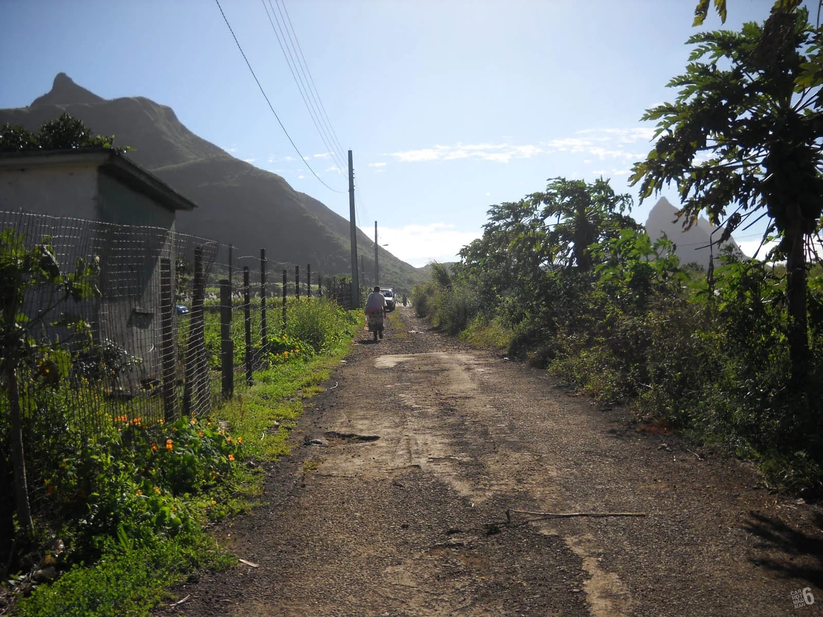
Where the start is
Le Pouce stands on the ridge between Port Louis and the Moka plateau, and its two documented routes start on opposite sides. The Petit Verger start is on the southern, Moka side, above the village of Saint-Pierre and a short drive from Moka, Eureka House and the Bagatelle junction. The car park sits at about 381 m, which is why this side gives the shorter climb. Wikipedia names La Laura-Malenga as the nearest village to the mountain, and the whole area is a patchwork of cane, small farms and vegetable fields with the thumb standing above them.
The start is marked on OpenStreetMap as a parking area at roughly -20.2076, 57.5270, and a local hiking guide gives almost the same coordinates. Save them to your phone before you set off, because the brown sign at the turn-off is small and easy to miss on a first visit, and one visitor summed the whole approach up as not well signposted.
Driving there from the motorway
Allow about 25 minutes from Port Louis and rather less from Moka or Ebène. The directions below are stitched together from the local walking guide and visitors’ accounts, and they are simple once you know what to look for.
Leave the motorway at Moka
From the M1 take the Mount Ory or Moka exit and head into Moka. Eureka House is signed from here and makes a useful landmark, because the road towards Saint-Pierre passes close to it.
Follow the B47 towards Saint-Pierre
Join the B47, also known as Bois Chéri Road, and continue towards Saint-Pierre. The mountain and its thumb are in view for most of the way, which helps you keep your bearings.
Watch for the sharp bend after the mosque
Shortly after a mosque the road makes a sharp bend. A small brown Le Pouce sign at the bend points up a narrow farm road. This is the turn, and most first-time visitors overshoot it at least once.
Take the farm road through the cane
The farm road is paved but narrow and climbs through cane fields with the thumb straight ahead. Drive slowly, because walkers and farm vehicles use it, and expect to meet cars parked on the verge at weekends.
Park at the end
The road ends at a small car park with space for four or five cars. Beyond it the route continues on foot along a wider farm track. If the car park is full, park tidily on the verge below without blocking the track, the fields or anyone else’s way out.
The car park, the verge and your valuables
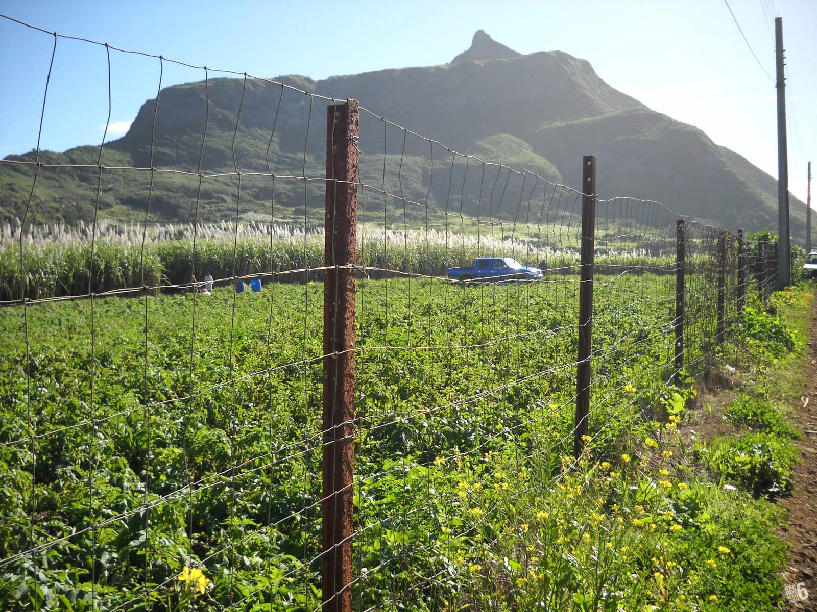
The car park is small, four or five cars by most counts, with more room on the verge of the farm road below it. Local walkers use the lower track every morning and the start fills early at weekends, so arrive early on a Saturday or Sunday for parking as well as for the weather and the summit queue. There is no fee, no barrier and no attendant, and nothing we found mentions toilets or water at this start.
Safe City cameras have been installed at the entrance of the lower track, which local walkers use as a health trail, according to a 2023 report in Le Mauricien. Cameras are not a guarantee. Leave nothing visible in the car, carry what you need and take your phone and keys up the mountain with you. Robberies on the mountain have been reported in recent years, so hike with company where you can and notice who is around the car park when you arrive in the half-light.
The wooden sign, the kiosk and the first waymarks
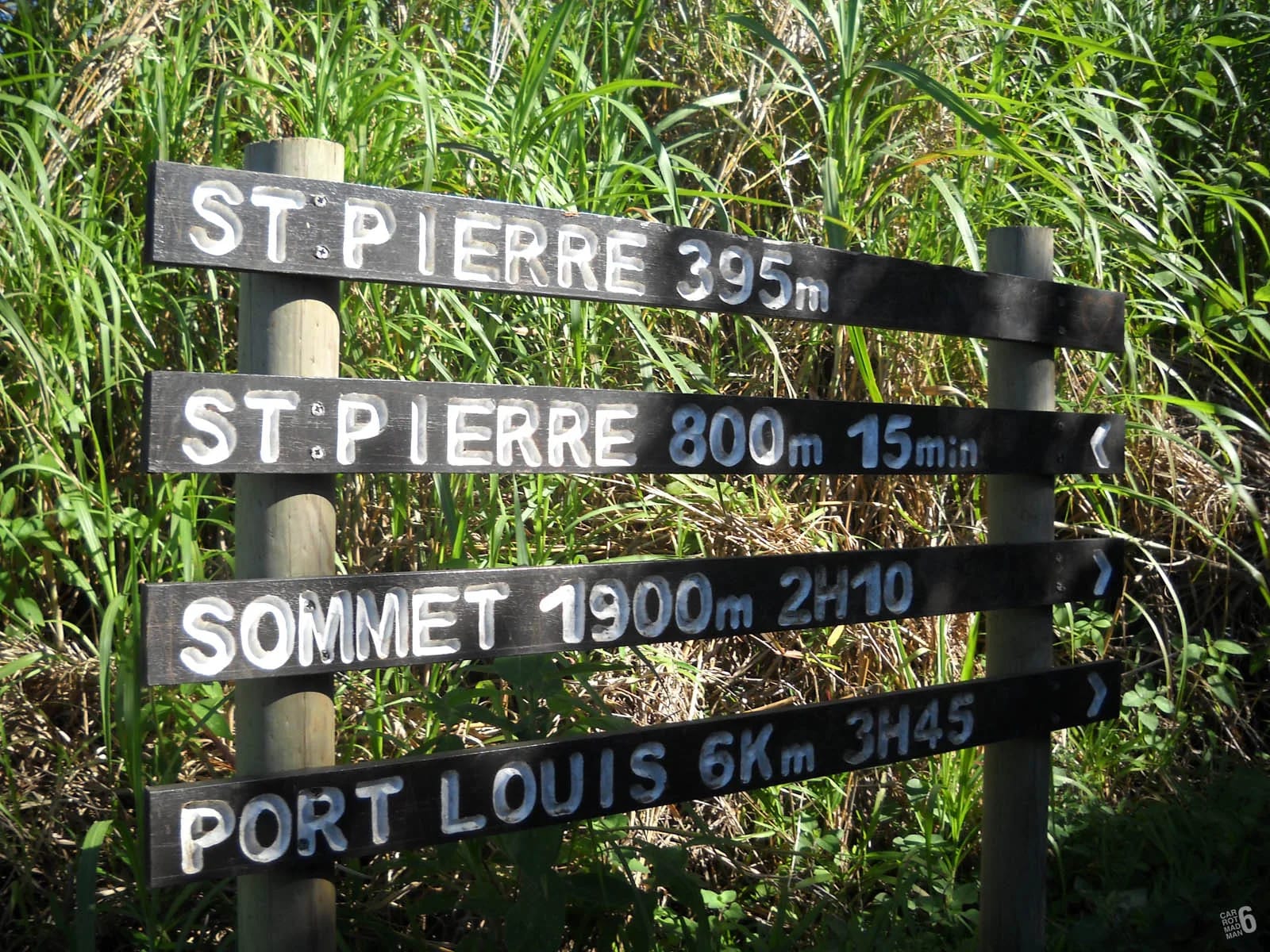
A wooden sign at the start lists the routes that leave from Petit Verger. It names the classic Le Pouce path, the longer route over to Le Dauguet on the Port Louis side, Le Grand Pouce and the Moka Range Challenge, the last two being long trail-running circuits rather than walks. You want the classic Pouce route. The first half kilometre is a wide farm track through the cane that local walkers use as an exercise loop, and it reaches a large kiosk at a junction at roughly 437 m. The waymarked summit path continues from the kiosk, and from here the blue and white paint on posts and trees is your guide.
The track is gentle and sunny, and it is a good place to settle into a rhythm and look up at the thumb. The forest closes in above the kiosk and the real climbing begins. The hike page describes every stage from here to the summit.
Getting there by bus
Saint-Pierre is served by regular buses, which makes Le Pouce one of the few Mauritian mountains you can reach without a car. The National Transport Corporation runs route 153 from Curepipe through Floréal, Vacoas, Quatre Bornes, Ebène, Réduit and Gentilly to Saint-Pierre, and route 167 from Henrietta through Ebène, Réduit, Moka and Gentilly to Saint-Pierre. From Port Louis, an individual-operator route 12 is listed from Victoria Square via Mount Ory, Moka and Bois Chéri Road to Saint-Pierre and on to Quartier Militaire, but the timetable we found is undated and we have not verified it. Ask at Victoria Square before relying on it.
Get off at Saint-Pierre Traffic Centre. From there the trailhead is a walk uphill through the village and along the B47 to the farm road. Nobody has measured it for us, but on the map it is a little over a kilometre, so allow about twenty minutes each way on roads without pavements. Country buses run roughly from 06:30 to 18:30, which rules out a dawn start by bus but suits a morning hike. The Metro Express reaches Réduit, where you can change to the Saint-Pierre buses.
| Route | From | Via | Status |
|---|---|---|---|
| NTC 153 | Curepipe | Floréal, Vacoas, Quatre Bornes, Ebène, Réduit, Gentilly | Listed by the National Transport Corporation |
| NTC 167 | Bord Cascades and Henrietta | Ebène, Réduit, Moka, Gentilly | Listed by the National Transport Corporation |
| Route 12 and 12A | Port Louis, Victoria Square | Mount Ory, Moka, Bois Chéri Road, Saint-Pierre | Undated timetable, not verified |
The other starting points
Petit Verger is one of two documented starts. The other is Tranquebar in Port Louis, where Chateau d’Eau Street ends below Le Dauguet, and it gives a route nearly twice as long with about 690 m of ascent. Le Mauricien names Tranquebar and Petit Verger as the two access points, and the same report describes Le Dauguet as a looped nature trail with parking and sanitary facilities from which a track also climbs Le Pouce. The Port Louis route page covers it in detail.
Wikipedia adds that the mountain can also be climbed from La Laura or Vallée des Prêtres, but we found no route description, waymark report or GPS recording for either, so treat them as local knowledge rather than visitor routes. One well-known guidebook places the trailhead at Le Dauguet near Eureka, which conflates the two sides of the mountain. Le Dauguet is on the Port Louis side, Eureka is near Moka, and the two starts are a mountain apart.
How far it is from the main bases
Petit Verger is close to the centre of the island, which makes it an easy morning from almost anywhere. We have not timed these drives ourselves, so treat the figures as rough guides and check a live map before you leave, particularly on weekday mornings when traffic into Port Louis and around the Moka junctions is heavy.
- Port Louis to the trailhead is roughly 20 to 25 minutes by car over the Moka road.
- Grand Baie and the north coast are roughly 45 minutes away.
- Flic en Flac on the west coast is roughly 40 minutes.
- The airport in the south-east is roughly 45 minutes on the motorway.
- Taxis charge by distance. Agree the fare and a return pick-up time with the driver before you start, because there is no taxi rank at the car park.
Questions people ask
Where do you park for the Le Pouce hike?
At the small car park at the end of the farm road above Saint-Pierre, at about 381 m and roughly -20.2076, 57.5270. It holds four or five cars, with more room on the verge of the farm road below. It is free, with no barrier or attendant. Arrive early at weekends, leave nothing visible in the car and take your valuables up the mountain with you.
Is the Le Pouce trailhead signposted?
Barely. A small brown Le Pouce sign stands at the sharp bend on the B47 after the mosque, pointing up the farm road, and visitors regularly overshoot it. Once you reach the car park a wooden sign lists the routes and the blue and white waymarks begin. Save the GPS position before you leave your hotel and the approach is straightforward.
Is there parking at Le Pouce at weekends?
Yes, but it fills early. Local walkers use the lower track as an exercise loop and the car park holds only four or five cars, so weekend arrivals after mid-morning usually end up on the verge of the farm road. Park tidily without blocking the track or the fields, and remember that the people who live and farm here need to get past.
Can I reach the Le Pouce trailhead by bus?
Yes. National Transport Corporation routes 153 from Curepipe and 167 from Henrietta serve Saint-Pierre via Réduit and Ebène, and an unverified route 12 runs from Victoria Square in Port Louis via Moka. Get off at Saint-Pierre Traffic Centre and walk uphill to the farm road, a little over a kilometre. Country buses run roughly 06:30 to 18:30.
Are there toilets at the Petit Verger start?
Nothing we found mentions toilets or water at the Petit Verger car park, and we would plan on there being none. Le Dauguet, the Port Louis trailhead, is reported to have sanitary facilities at its sports ground. Use the facilities in Moka or Saint-Pierre before you drive up, and carry all the water you will need.
Which start should I choose, Petit Verger or Port Louis?
Petit Verger for most people. It starts at 381 m, so the climb is about 390 m over 2 km and the round trip takes 2 to 3 hours. The Port Louis start at Tranquebar is at about 88 m and the route is 3.6 km with about 690 m of ascent, shadier and more gradual but much longer. Choose Port Louis if you want a full morning, or a through-hike by bus.
Now walk it
The hike page takes you from this car park to the summit stage by stage, with the map, timings and the honest word on the finish.