
History of Le Pouce
Le Pouce has no battle, no fort and no recorded first ascent. Its history is quieter, a name that describes its shape, a run of artists and scientists who drew it or climbed it between the early 1800s and 1861, a nature reserve declared in 1951 and a long Mauritian habit of walking up it. This page sets out what is documented and says plainly where the record goes blank.
Read the guide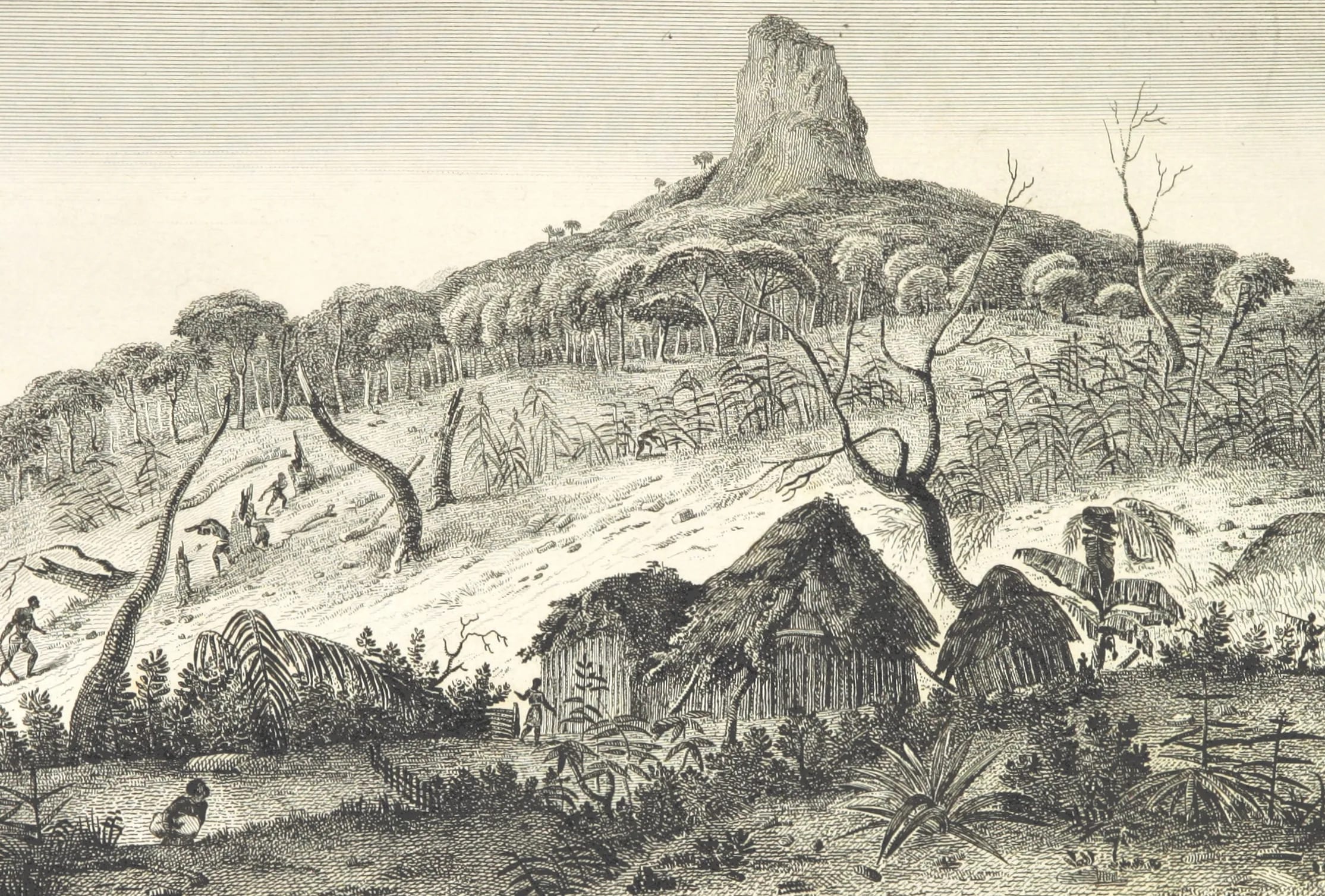
Where the name comes from
Le Pouce means the thumb, and the mountain is named for the short upright rock at the end of its long ridge, which looks like a thumb raised from the back of a hand when you see it from Port Louis. The earliest dated explanation of the name is Charles Darwin’s. Writing up his climb of early May 1836 he described “a mountain so called from a thumb-like projection”, and he spelled it “La Pouce”, although the French word is masculine and Le Pouce is correct.
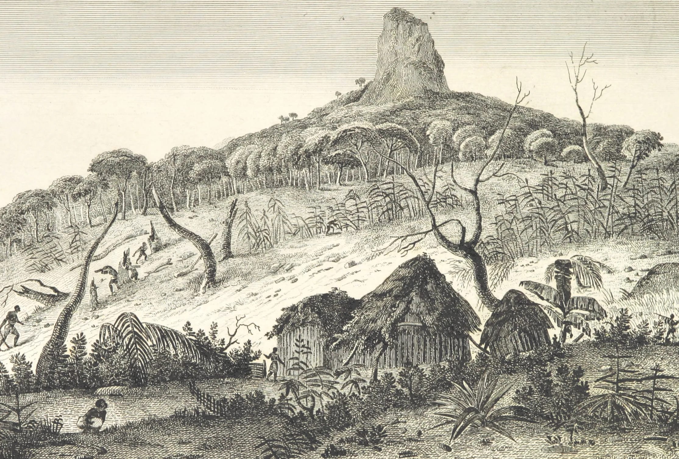
The name itself is older than Darwin. The atlas of Jacques-Gérard Milbert’s Voyage pittoresque à l’Île de France, published in Paris in 1812, carries a plate titled “Vue de la Montagne du Pouce”, so the name was in print, and presumably in daily use, in the last years of French rule. Before that the trail goes cold. This guide has found no eighteenth-century map label for the mountain and no Dutch-era name, and no one seems to know who first saw a thumb in it. If an earlier record exists, it is not online.
Milbert in 1812 and Bérard in 1861
Milbert was an artist on Nicolas Baudin’s expedition of 1800 who left the voyage at Île de France when illness and quarrels broke up the party, and he stayed on the island long enough to draw it thoroughly. His atlas of 1812 contains 45 views, engraved in part by Testard, and three of them are of this mountain: a view of the Montagne du Pouce, a view of the Plaines Wilhems taken at its base and a view taken in its woods. There are also two views of Pieter Both and several of Port Napoléon, the name the capital carried under the Empire. They are the earliest known images of Le Pouce and show it rising over forest and plantation rather than suburbs.
Half a century later the mountain reached a wider public. In 1861 the Paris travel journal Le Tour du Monde published an engraving titled “Île Maurice. Le Pouce” after Évremond de Bérard in its fourth volume. The image is in the public domain and is the picture most often reproduced when the mountain’s history comes up. Between those two dates French Île de France had become British Mauritius, slavery had ended and the indentured labour system had begun, and the view from the thumb had changed with them.
Flinders on the shoulder
Matthew Flinders, the navigator who had just completed the first circumnavigation of Australia, put in to Baie du Cap on 15 December 1803 and was detained by Governor Decaen on suspicion of spying. He was held on the island until 1810, or June 1809 according to one source, spending part of his detention in the Plaines Wilhems, from where he dated a letter in April 1806. The National Maritime Museum in Greenwich holds a pencil drawing by him catalogued as a view looking towards the sea from the shoulder of Le Pouce. It is undated.
That drawing is the only evidence connecting Flinders to the mountain, and it should be read carefully. It proves he reached the shoulder, the grassy platform below the thumb from which Port Louis and the sea open out, and sat there long enough to draw. It does not prove he went up the final spur, and nothing in his papers that this guide has seen says he did. He is best described as the first known visitor to the shoulder, not as an early summiteer.
Darwin’s climb in 1836
HMS Beagle anchored at Port Louis on 29 April 1836 and sailed on 9 May. In between, Charles Darwin climbed Le Pouce, most sources say on 2 May, estimated its height at 2,600 feet and wrote the few sentences about the thumb, the view and the sugar boom that every later account of the mountain quotes. His is the earliest dated ascent of Le Pouce that this guide has found, which does not make it the first. The Darwin page on this site quotes his text and follows his other excursion, half of it on the Surveyor-General’s elephant.
No first ascent on record
Mountaineering history likes first ascents, and Pieter Both next door has one. On 7 September 1832 Captain John Augustus Lloyd, Lieutenant Phillpotts of the 29th Regiment, Lieutenant Keppel of the Royal Navy and Lieutenant Taylor reached its balanced summit boulder, and the date has been repeated ever since. Le Pouce has nothing of the kind. Its summit can be reached on foot with a hand or two on the final rocks, and it was very probably climbed by people living below it long before anyone thought the fact worth writing down.
The sequence of documented visitors is therefore Milbert at its base and in its woods in the early 1800s, Flinders on the shoulder before 1810, and Darwin on the summit in 1836. Lloyd, the man of the Pieter Both ascent, was also the man who lent Darwin his elephant four years later, so British officers of the 1830s were plainly interested in both mountains. If a Mauritian archive holds an earlier ascent account, it has not surfaced in anything this guide could find.
The nature reserve of 1951
In 1951 the colonial government declared Le Pouce Nature Reserve on the north-western flank of the mountain, 0.69 km² of native cloud forest, at the same time as the small Cabinet and Perrier reserves elsewhere on the island. It is now listed in the Second Schedule of the Forests and Reserves Act of 1983 and managed by the Forestry Service, and a 2003 amendment allows the authorised officer to restrict access to any nature reserve, although no closure notice for Le Pouce has been found for 2023 to 2026. The reserve protects the only significant native vegetation in the Moka Range and several critically endangered plants, including a screwpine known from two individuals. Its story, and the pressures on it, are on the nature page.
The mountain in Mauritian life
For most of its history Le Pouce was simply the mountain behind the capital, climbed by people who lived under it. That is still true. Local reporting describes walkers on the Saint-Pierre side every day, and the wooden sign at the start lists not only the classic route but Le Dauguet, Le Grand Pouce and the Moka Range Challenge, a measure of how many ways people now use the ridge. Safe City cameras watch the entrance to the health track.
The mountain has also become a shared rite of passage. In April 2016 about 500 teenagers from the island’s youth centres climbed Le Pouce and Piton de la Petite Rivière Noire in a single organised outing. The Moka Trail races have used the ridge in recent years, with a Grand Pouce course of about 30 km and 1,500 m of climbing and a shorter Petit Both course that turns at the col between Le Pouce and Pieter Both. In 2020 a Mauritian runner, Giovanni Vadamootoo, climbed the mountain sixteen times in just under 24 hours, covering 67.72 km and 6,912 m of ascent. And with the growth of tourism the thumb has become one of the first things visitors staying in the north or in Port Louis go up, which is why this guide exists.
The dated record at a glance
Everything in the table below is documented. The gaps between the rows, above all the whole eighteenth century and the Dutch period, are real gaps in the record and not omissions.
| Date | Event | Evidence |
|---|---|---|
| Early 1800s | Jacques-Gérard Milbert draws the mountain, its base and its woods | Plates in his atlas of 1812 |
| 1803 to 1810 | Matthew Flinders detained on the island; pencil drawing from the shoulder of Le Pouce | National Maritime Museum, Greenwich |
| 1812 | Milbert’s Voyage pittoresque published in Paris with “Vue de la Montagne du Pouce” | Atlas plates on Wikimedia Commons |
| 7 September 1832 | First recorded ascent of neighbouring Pieter Both by Lloyd, Phillpotts, Keppel and Taylor | Encyclopaedic entry for Pieter Both |
| Early May 1836 | Charles Darwin climbs Le Pouce; earliest dated explanation of the name | Journal of Researches, chapter 21 |
| 1861 | Engraving “Île Maurice. Le Pouce” after Évremond de Bérard in Le Tour du Monde | Wikimedia Commons |
| 1951 | Le Pouce Nature Reserve declared, 0.69 km² | Protected Planet and the encyclopaedic entry |
| April 2016 | About 500 youth-centre teenagers climb Le Pouce and the Piton | Le Mauricien |
| July to August 2020 | Giovanni Vadamootoo makes 16 ascents in 23 h 56 min | Le Défi Media |
Questions people ask
Who first climbed Le Pouce?
Nobody knows, and no source claims to. Unlike Pieter Both, whose first recorded ascent was made on 7 September 1832 by a party of British officers, Le Pouce has no first-ascent record at all. The earliest dated climb this guide has found is Charles Darwin’s in early May 1836, and local people had almost certainly been up long before that.
Why is it called Le Pouce?
Because the summit rock looks like a thumb raised from the back of a hand, which is what pouce means in French. Darwin gave that explanation in 1836 and it is the earliest dated one. The name itself appears in print by 1812, on a plate in Milbert’s atlas of Île de France, so it was in use under French rule. Who coined it is not recorded.
Did Darwin climb Le Pouce?
Yes. He walked up during HMS Beagle’s stop at Port Louis between 29 April and 9 May 1836, most sources say on 2 May, and described the thumb-like projection, the view over the cultivated island and the sugar economy in his Journal of Researches. The Darwin page on this site quotes his words and explains the uncertainty over the exact day.
Did Matthew Flinders climb Le Pouce?
He reached the shoulder. The National Maritime Museum holds his undated pencil drawing of the view towards the sea from the shoulder of Le Pouce, made at some point during his detention on the island from December 1803 to 1810. There is no evidence that he continued up the final spur to the summit, so he should not be described as having climbed the mountain.
Is there a legend about Le Pouce?
None that this guide could find. The legend of the Moka Range belongs to Pieter Both next door, where a milk seller named Shyantak was said to have watched fairies dancing, broken his vow of secrecy and been turned to stone on the summit, with a later belief that the British would leave the island when the head rolled off. Le Pouce has no equivalent story on record.
When did Le Pouce become a nature reserve?
In 1951, when 0.69 km² of cloud forest on the north-western flank was declared Le Pouce Nature Reserve along with two other small reserves on the island. It is now listed under the Forests and Reserves Act of 1983 and managed by the Forestry Service. The reserve protects the only significant native forest left in the Moka Range.
Read what Darwin wrote
The Darwin page quotes his account of the thumb, the view and the sugar island of 1836 and shows what a hiker can still recognise.