
Le Pouce Mountain, Mauritius
Le Pouce is the thumb-shaped summit that stands directly behind Port Louis, in the middle of the Moka Range. At 812 m it is the third-highest mountain in Mauritius, a few metres below Pieter Both and Piton de la Petite Rivière Noire, and the only one of the three that most walkers can reach without ropes, a guide or a long drive.
Read the guide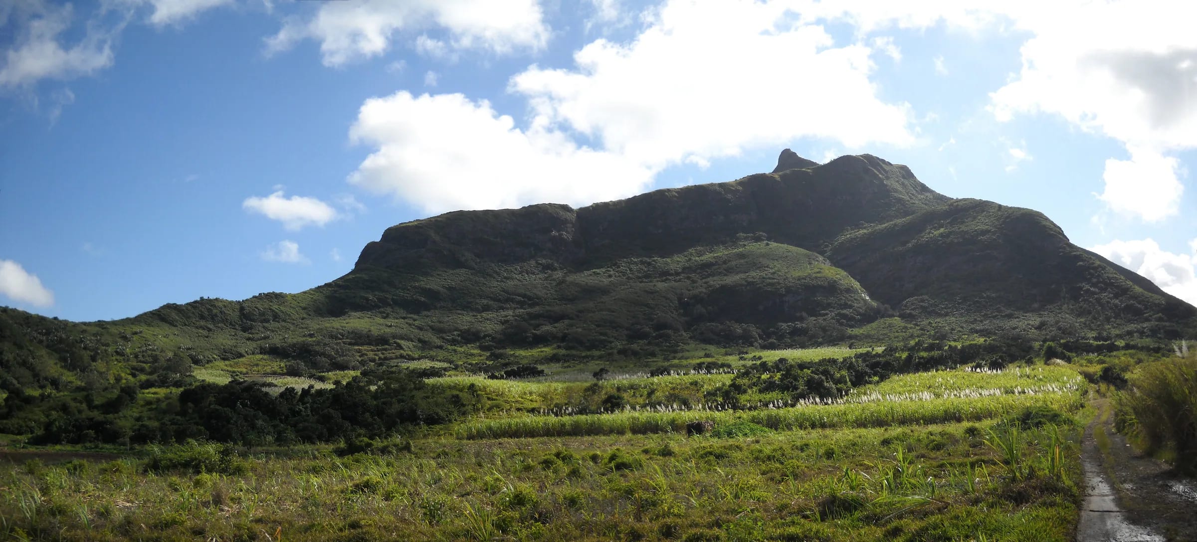
Why it is called the thumb
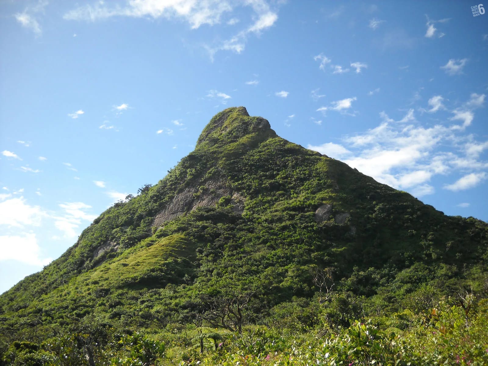
Seen from the harbour at Port Louis, from the motorway north of the capital or from the stands of the Champ de Mars, the mountain reads as a hand lying palm down. The long, slightly rounded ridge is the back of the hand and the short upright knob of rock at its end is the thumb, lifted a little above everything else. Le Pouce is simply the French word for thumb. Montagne du Pouce is the full name, and Mauritians use both without thinking about it.
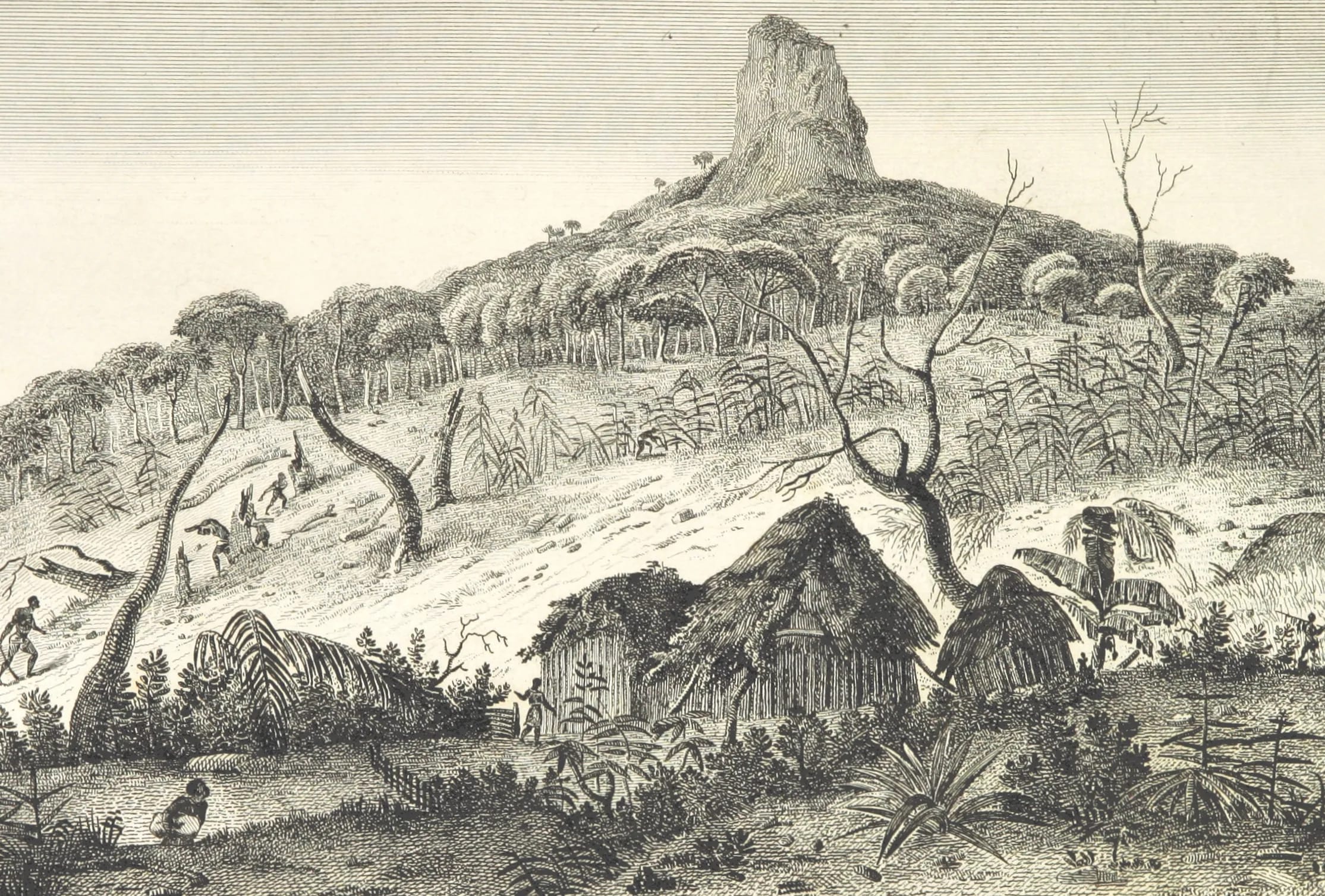
The earliest dated explanation of the name is Charles Darwin’s. Writing up his climb of early May 1836, he called it “a mountain so called from a thumb-like projection”. The name itself is older. Jacques-Gérard Milbert’s picture atlas of Île de France, drawn during a stay on the island at the start of the century and published in Paris in 1812, already has a plate titled “Vue de la Montagne du Pouce”, with two more taken at its base and in its woods. Nobody has found an earlier map label or a Dutch-era name, so the honest summary is that the shape named the mountain some time in the French period and the name has never needed changing.
How high it really is
The accepted height is 812 m, or 2,664 feet. That is the figure in the main encyclopaedic entry, on the OpenStreetMap summit node and in the Key Biodiversity Area factsheet for the Moka Mountains. Tour listings sometimes give 811 m. Wikipedia’s own overview page on the geography of Mauritius lists Le Pouce at 820 m, which would make it level with Pieter Both, and this guide treats that as an inconsistency between pages rather than a rival measurement. Darwin estimated 2,600 feet in 1836, about 790 m, which was a good guess for a man with no instrument but his eye.
Prominence, the height of the summit above the lowest col that connects it to higher ground, is quoted as 232 m in one source and as about 334 m to 352 m in others, depending on which saddle is used. For a hiker the figure that matters is different again. From the Petit Verger car park at about 381 m the climb is roughly 390 m on the mapped route, and from Tranquebar in Port Louis it is about 690 m.
Whichever figure you take, Le Pouce sits in a tight group with the island’s two higher summits. Piton de la Petite Rivière Noire, in the Black River Gorges National Park, reaches 828 m. Pieter Both, visible along the ridge to the east, reaches 820 m, or 823 m in the BirdLife and KBA factsheets. The gap between first and third place is 16 m.
| Mountain | Height | Character |
|---|---|---|
| Piton de la Petite Rivière Noire | 828 m | Highest point, forested walk in the national park |
| Pieter Both | 820 m | Roped climb to a balanced boulder, guide needed |
| Le Pouce | 812 m | Walk with a steep, exposed summit finish |
| Montagne Bambou | about 630 m | High point of the Bambous range in the east |
| Snail Rock | 620 m | Le Pouce’s neighbour to the west on the Moka ridge |
| Trou aux Cerfs | about 605 m | Dormant crater rim with a road to the top, Curepipe |
| Le Morne Brabant | 556 m | UNESCO landscape, guided upper section |
| Lion Mountain | about 480 m | Short, steep, exposed ridge above Vieux Grand Port |
Where it stands
The summit lies at roughly 20°11′50″ S, 57°31′43″ E, a little under 4 km in a straight line from the racecourse at the Champ de Mars. The Moka Range of which it is part forms a semicircle of sharp peaks around Port Louis, about 20 km long, with a main east-to-west ridge and three spurs running north towards the sea. Le Pouce is the second-highest point on that ridge after Pieter Both, which stands about 2.7 km to the east-north-east. Snail Rock, 620 m, is the next summit to the west-north-west, and Guiby Peak, Berthelot Peak and Montagne Ory are the other named summits around it.
Administratively the mountain belongs to Moka district, with La Laura-Malenga given as the nearest village, although its northern face drops straight into Port Louis district and at least one peak database lists it under both. In practice there are two sides. The south side faces Moka, Saint-Pierre and the cane fields of Petit Verger, where the standard trail begins. The north side faces the capital, with the suburbs of Tranquebar and Le Dauguet at its foot and the longer northern trail climbing out of them.
The nature reserve on its flank
In 1951 the north-western flank of the mountain became Le Pouce Nature Reserve, 0.69 km² managed by the Forestry Service and listed in the Second Schedule of the Forests and Reserves Act. It is small, but it protects the only significant patch of native cloud forest left in the whole Moka Range, kept wet by the cloud that so often sits on the summit. Botanists have recorded several critically endangered plants here, including a screwpine, Pandanus pseudomontanus, known from just two individuals in the world, both of them male and both in this reserve.
The reserve is also under real pressure from Chinese guava, jamrosa, introduced monkeys and the litter that earned the summit the nickname Bottle Mountain in the local press. The nature page on this site goes into what lives here and what visitors can do. The short version is to stay on the path, carry everything down and leave the plants alone.
What the mountain has witnessed
Le Pouce has no battle, no fort and no recorded first ascent, but it has been drawn and climbed by a remarkable run of visitors. Matthew Flinders, the navigator who charted much of the Australian coast, was detained on the island by Governor Decaen from December 1803 until 1810, and the National Maritime Museum in Greenwich holds his undated pencil drawing of the view towards the sea from the shoulder of Le Pouce. That is evidence that he reached the shoulder, not proof that he stood on the thumb.
Milbert’s atlas of 1812 gives the earliest known images of the mountain, alongside views of Pieter Both and of Port Napoléon, as Port Louis was briefly called. In 1832 Captain John Augustus Lloyd, the Surveyor-General, was in the party that made the first recorded ascent of Pieter Both next door, and four years later he lent Charles Darwin his elephant for an excursion to Rivière Noire. Darwin climbed Le Pouce on foot in early May 1836 and wrote about the view, the sugar boom and the geology of the ring of mountains. In 1861 the Paris travel journal Le Tour du Monde published an engraving of the peak after Évremond de Bérard. Today the mountain is climbed every day of the week, forms part of the Moka Trail race courses and has Safe City cameras at the entrance to the health track in Saint-Pierre.
How it fits a visit
Le Pouce is a half-day mountain, and a very convenient one. From the Petit Verger car park the climb and return take 2 to 3 hours for most people, or 3 to 4 with a proper stop on top. That leaves the afternoon for Eureka, the Creole mansion of 1830 ten minutes from the trailhead, for the villages of Moka and Saint-Pierre, or for the market, Aapravasi Ghat and the Citadel in Port Louis, which you will have been looking down on all morning. The northern route from Tranquebar is a longer, shadier climb of about 690 m and makes a full morning on its own.
If you only read one other page, read the hiking guide. The farm track, the forest and the grassy shoulder are easy, and the final spur to the thumb is not. Knowing that before you start, and being willing to stop at the shoulder, is the whole secret of enjoying this mountain.
- Start early. The upper mountain is open to the sun and the wind, and the car park fills at weekends.
- Carry at least 1.5 litres of water per person. There is no water on the route.
- Wear shoes with real grip. The path is rocky, and muddy and slippery after rain.
- Skip the final spur in strong wind or low cloud. The shoulder view is excellent on its own.
- The summit is small. It is comfortable for about six people and crowded above ten, so sit down and leave room.
Questions people ask
Is Le Pouce the highest mountain in Mauritius?
No. It is the third-highest at 812 m. Piton de la Petite Rivière Noire in the south-west is the highest at 828 m and Pieter Both, along the same ridge to the east, is second at 820 m. Le Pouce is the highest of the three that can be walked up without climbing equipment, which is why it is the one most visitors actually climb.
Which district is Le Pouce in?
Moka district, with La Laura-Malenga given as the nearest village in the main encyclopaedic entry. The mountain forms the boundary with Port Louis district, whose suburbs of Tranquebar and Le Dauguet sit at its northern foot, and some peak databases list it under both. The standard trailhead at Petit Verger, above Saint-Pierre, is in Moka.
Can you see Le Pouce from Port Louis?
Yes, easily. It is the thumb-shaped summit at the back of the ring of mountains behind the city, and Darwin described it as rising close behind the town. The Champ de Mars, the Caudan waterfront and the motorway approaches all give clear views, and the profile is sharpest in the low light of early morning or late afternoon.
Is Le Pouce a volcano?
Not in the sense of a crater you can walk around. It is part of the eroded rim of the oldest volcanic shield of Mauritius, built roughly ten to five million years ago and long extinct. Darwin saw the ring of mountains around the central plateau as the broken remains of that old structure, and modern geology agrees in outline. The geology page explains the rock and the ages in detail.
Is Le Pouce the same mountain as Pieter Both?
No. They are neighbours on the same ridge about 2.7 km apart and are often photographed together, but they are very different summits. Pieter Both ends in a balanced boulder that needs ropes and a guide. Le Pouce ends in a narrow rock thumb that most walkers can reach with a hand or two on the final step.
Is Le Pouce worth climbing if I have done Le Morne?
Yes. Le Morne is a managed heritage site on the south-west coast with a guided upper section and a view over a lagoon. Le Pouce is free, waymarked, higher by about 250 m, and looks down on a capital city, a harbour and the whole northern plain. It is also far quicker to reach from Port Louis, Moka and the north coast hotels.
Ready to plan the climb?
The hiking guide walks the Petit Verger route stage by stage, from the farm track to the thumb, with honest notes on the steep finish.