
Geology of Le Pouce
Le Pouce is not a volcano of its own. It is a surviving piece of the oldest volcanic shield of Mauritius, part of the broken rim of basalt that curves around Port Louis and that Charles Darwin recognised in 1836 as the remains of something much larger. This page explains what the rock is, how old it is, why the thumb stands up on its own and what it feels like under your boots.
Read the guide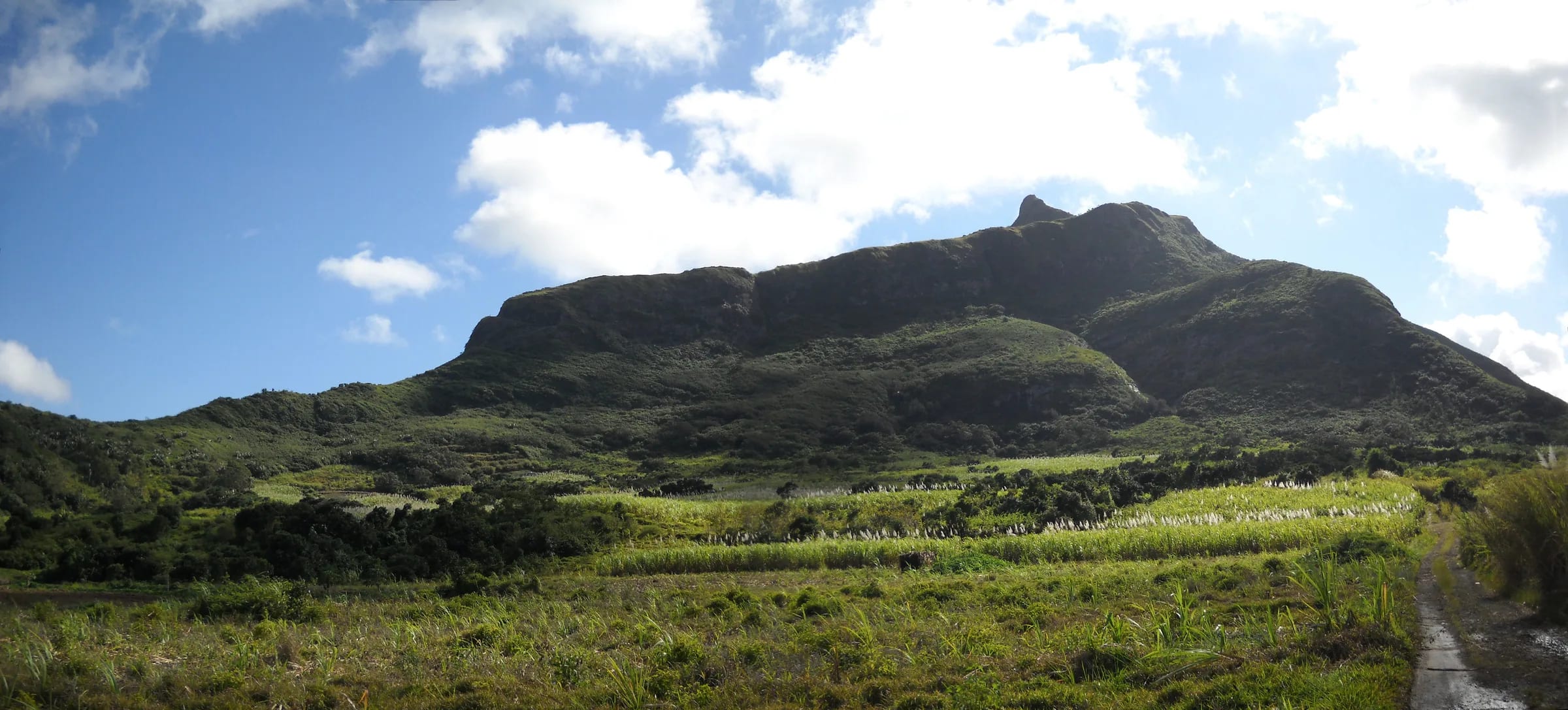
An island built by a hotspot
Mauritius is a volcanic island raised from the floor of the Indian Ocean by the same hotspot that feeds the active volcano on Réunion today. Geologists divide its rocks into three basaltic phases. The Older Series built the first great shield and is dated to between 9.0 and 4.7 million years ago in the standard summaries, with the first land emerging about ten million years ago as the so-called Breccia Series. The Intermediate Series, from 3.5 to 1.66 million years ago, and the Younger Series, from about one million down to about 30,000 years ago, then poured fresh lava over the centre of the island and built the plateau that most Mauritians live on. Nothing has erupted since, and the island’s volcanoes are extinct.
Le Pouce belongs to the first of those phases. Everything you walk on between Petit Verger and the thumb is Older Series rock, which is why it is so deeply cut and so sharply shaped compared with the gentle slopes of the younger plateau to the south.
| Series | Age | What it built |
|---|---|---|
| Breccia Series | About 10 million years | The first land to emerge above the sea |
| Older Series | 9.0 to 4.7 million years, or 7.8 to 5.4 in Paul and colleagues (2007) | The first shield; the Moka Range and the island’s other old mountain ranges, including Le Pouce |
| Intermediate Series | 3.5 to 1.66 million years | Lavas over the centre of the island |
| Younger Series | 1.0 million to about 30,000 years | The central plateau and the youngest lava flows |
The old rim around Port Louis
The Moka Range is a piece of the Older Series shield that the younger lavas never buried. Together with the mountains of the south-west and the ranges of the east, it forms the broken ring that Darwin saw from the summit, old mountains with their lava layers tilted outward towards the sea around a younger plateau in the middle. Around Port Louis that ring is a semicircle of sharp peaks about 20 km long, with a main east-to-west ridge and three spurs running north. Le Pouce and Pieter Both are its two highest points, and Snail Rock, Guiby Peak, Berthelot Peak and Montagne Ory are the others.
Several million years of heavy tropical rain have cut the original dome down to these ridges and carved out the valleys between them, including the bowl in which the capital sits. The encyclopaedic entry for the range describes it as formed from a basalt lava dome about ten million years ago, which is a fair one-line summary provided you remember that what you see today is the eroded skeleton of that dome, not the dome itself.
How old the rock is
No one has published a radiometric date for a sample taken on Le Pouce itself, so the honest answer is a range. The encyclopaedic entry for the mountain describes it as a basalt lava dome about ten million years old. The standard geological summary puts the whole Older Series between 9.0 and 4.7 million years. A 2007 study by Paul and colleagues narrows the main Older Series eruptions to between 7.8 and 5.4 million years ago and dates one trachyte plug associated with those basalts very precisely to 6.849 million years, give or take 12,000 years.
Taken together, the rock you walk on is roughly ten to five million years old. That makes Le Pouce very old for a mountain on a volcanic island, and it explains how thoroughly the mountain has been eroded. Réunion, by comparison, is still being built, and the youngest Mauritian lavas are only a few tens of thousands of years old.
Basalt, trachyte and the plugs
The Older Series is not a single rock. It includes olivine basalt lava flows, agglomerate made of welded volcanic fragments, intrusions of pale trachyte and plugs of trachyandesite that once filled the throats of vents. Darwin, who looked at the hills around Port Louis with a geologist’s eye, noted in his geological diary that they were made of basalts and black trachytes, with solid layers alternating with cemented fragmentary rock, and he put the detached hills around the central plain at generally two to three thousand feet.
The sharp, serrated skyline of the Moka Range, which Darwin described on arrival as peaks “jagged into the sharpest points”, is what you get when layers of hard lava and softer agglomerate, cut through by even harder intrusions, are eroded for millions of years under heavy rain. The hard parts stand up as peaks and knobs. The soft parts become the slopes, the cols and the clay-rich soil that sticks to your boots.
Why the thumb stands alone
The thumb is a resistant remnant. The ridge below it is the back of the hand, a strip of the old shield worn down to a long grassy shoulder, and the knob at the end is a mass of harder rock that has outlasted the material around it. That is the general mechanism behind every sharp peak in the range, and it is as far as the published evidence goes. Whether the summit rock of Le Pouce is a particularly dense basalt flow or a trachyte intrusion has not been established in any study this guide could find, and it is better to say so than to guess.
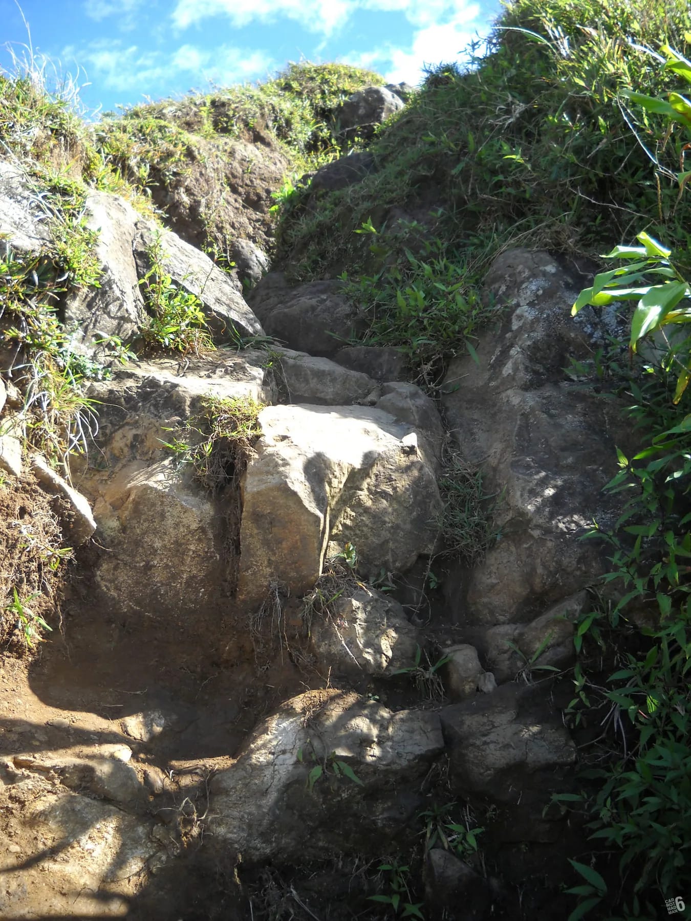
What you can see for yourself is that the rock of the final spur is darker, blockier and far more resistant than the crumbly, clay-rich slopes you crossed lower down, and that the drops on either side of it are the result of everything softer having been stripped away. The exposure that makes the last 30 m feel serious is the same process that made the mountain worth climbing.
Darwin’s reading of the ring of mountains
Darwin reached Mauritius in 1836 near the end of the Beagle voyage, already thinking hard about volcanic islands and coral reefs. From Le Pouce and the country around it he concluded that “The centre of the island consists of a great platform, surrounded by old broken basaltic mountains, with their strata dipping seawards”. A fashionable theory of his day, the craters of elevation, held that rings of outward-dipping mountains like this had been heaved up bodily from below. Darwin noted that Mauritius fitted the description, and then distanced himself from the explanation: “There appears to me to be insuperable objections to this view”.
Modern geology has sided with him in outline. The outward dip of the layers is the original slope of a shield volcano, the ring is what erosion has left of that shield, and the central platform is younger lava that flooded the interior afterwards. His observation was good; only the dating and the mechanism had to wait for another century of work.
What the rock is like underfoot
The geology turns practical the moment it rains. The lower trail from Petit Verger follows a farm track and forest switchbacks on weathered basalt and a thin, clay-rich soil that drains slowly, so the path is rocky in dry weather and muddy and slippery after rain, and hikers describe very muddy descents. Where the route is cut into rock there are smooth steps polished by many feet. The grassy shoulder is easier walking, but it is also where the wind arrives.
The final spur is bare rock, blocky and sound in the dry but greasy when wet, with a trench along the ridge for the last 30 m or so and a step that needs a hand or two. Morning fog alone is enough to make it slippery. Shoes with a real sole matter more here than anywhere else on the mountain, and a wet day is a good day to be content with the shoulder.
- Dry weather: rocky and firm, with polished steps where the path is cut into rock.
- After rain: slow-draining clay turns the lower path to mud and the final rocks become greasy.
- In fog or cloud: the summit spur is slippery even without rain, so stop at the shoulder.
- Always: the drops either side of the final spur are real, because the softer rock around it is gone.
Questions people ask
Is Le Pouce a volcano?
Not in the sense of a cone or a crater. It is a piece of the eroded rim of the first shield volcano that built Mauritius, roughly ten to five million years ago. The crater you can walk around in Mauritius is Trou aux Cerfs at Curepipe, which belongs to the much younger lavas of the central plateau.
Is Le Pouce still active?
No. The whole of Mauritius is extinct. The Older Series rocks that make up Le Pouce stopped erupting several million years ago, and even the youngest lavas on the island are tens of thousands of years old. The nearest active volcano is on Réunion, about 200 km to the south-west.
What rock is Le Pouce made of?
Mainly basalt from the Older Series, with agglomerate and intrusions of trachyte and trachyandesite in the sequence. Darwin recorded basalts and black trachytes in the hills around Port Louis. No study has published exactly which rock forms the summit knob itself, so this guide describes it as hard, dark, resistant volcanic rock and leaves it there.
How old is Le Pouce?
Roughly ten to five million years. The encyclopaedic entry says about ten million years, the standard summary of Mauritian geology puts the Older Series at 9.0 to 4.7 million years, and a 2007 study narrows the main eruptions to 7.8 to 5.4 million years. No one has dated a sample from Le Pouce itself.
Why is Le Pouce shaped like a thumb?
Because a mass of harder rock at the end of the ridge has resisted erosion while the softer material around it was stripped away over millions of years. The long ridge is the back of the hand, worn down to a grassy shoulder, and the thumb is the remnant. The same process made the balanced boulder of Pieter Both next door.
Is the rock on Le Pouce slippery?
After rain, yes, and often in morning fog as well. The lower path crosses clay-rich soil that turns to mud, and the final rock spur becomes greasy when wet. In dry weather the rock is firm and grippy. Wear shoes with a proper sole and be willing to stop at the shoulder on a wet day.
Read what Darwin wrote
The Darwin page quotes his account of the thumb, the view and the ring of mountains he worked out from the summit in 1836.